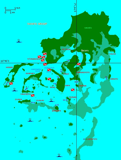
Our anchorages and dive locations throughout the Vava'u Group.
Click on a flag to go to a description of that dive
|
Pacific Landfalls Tonga Pages Related Pages |
Vava'u Map
Map by Amanda Hacking Our anchorages and dive locations throughout the Vava'u Group. Click on a flag to go to a description of that dive |
Vava'u Anchorages and Dives
In the map to the right, the darker areas are land, the lighter areas are water, and the intermediate color is for the (extensive) reefs. As a general rule, these reefs were shallow enough that even Ocelot, with her 4' (1.2m) draft, could not sail over them. Since the electronic charts of Tonga are all very inaccurate (out by 1/4 mile or 500m), we had to pay a lot of attention to our navigation.
Click on the red and white dive flags to go to our description of that dive.
Cruisers: See our Track Files below. Note that these files are WGS84 compliant, so they may not match the CM93 charts. As of 2011, all CM93 charts seem to be out by at least 1/4 mile for all of Tonga. If you're using OpenCPN, we suggest that you adjust the charts a bit south and more east (instructions are in the Help files).
In Vava'u, anchorages are frequently referred to by their "Moorings number," the number Moorings Charters gives to their clients (what's printed on the maps they give out). We occasionally refer to anchorages by number and name interchangeably. To reduce confusion, here's a list of the anchorages we went to and their numbers:
| 5 | "Around the corner" from Neiafu |
| 6 | Mala |
| 7 | Port Maurelle |
| 8 | Nuku |
| 11 | Tapana |
| 14 | Blue Lagoon |
| 16 | Vaka'eitu (Coral Gardens) |
| 22 | Taunga |
| 30 | Kenutu |
| 32 | Euakafa |
| 40 | Ovalau |
| Luatafito | Not a "Moorings Approved" anchorage, so no number |
About the Whales: Humpback whales migrate to Tonga every year to mate and breed. During the months of July-October, these magnificent creatures inhabit this group of islands, and we frequently saw several even just on short day-sails. They are most abundant around the southern islands and west of the group, but in the height of season we saw them all around Euakafa, between Hunga and Nuapapu, and even right outside Port Maurelle. Around Euakafa and Matuku in the Ha'apai, we could occasionally hear whale-song through the hull of the boat! Who needs a mic when you can press your ear to the floor and feel the thrumming in your chest? By far the greatest amount of whales we saw was on the day-sail down to the Ha'apai. I think we saw six pods, and once watched a single whale just diving and breaching for about half an hour. Enchanting!
|
Tonga Tracks
Diving Vava'u: We went diving several times with Dolphin Pacific Diving, especially when they were doing a cheaper monthly "club dive," but several of our dives in the Vava'u Group were independent ones that we did with other cruisers. Because air-fills were so inexpensive, we tried to never return to Neiafu with full tanks, but much to Chris' disappointment, that didn't always happen. The five independent dives we did out in the outer islands were a bommie south of Tapana, inside Blue Lagoon (#14), the Clan MacWilliam wreck in Neiafu, a bommie south of Vaka'eitu, and off Ava Island (SW of Port Maurelle #7). The rest of our dives - most around Tu'unga'sika Island at the north-west entrance to the Vava'u Group - were with Dolphin Pacific Diving. Cruisers: We are now publishing Downloadable Track Files in OpenCPN (.gpx) format and in MaxSea (.ptf) format (not all tracks are available in all formats yet - we're still working on it and they take time). You can download the track files either by clicking on the links in the tables below, or by clicking on the track in the Google Map below the table. The MaxSea files are in native format but the OpenCPN files are zipped so they download faster, and they need unzipping after they've been downloaded (which most operating systems do natively). If 2 files are shown, the smaller one has been edited to remove redundant points from straight tracks. This improves the speed of the download as well as performance once the file is loaded. Sometimes MaxSea Track files are separated from the Mark (chart notations) files. Download instructions are provided if you need them. These files are provided free and we are actively soliciting cruisers to send us your track files so we can post them for others to download. If you would like to to participate, please email us your track files (as attachments to our HackingFamily account, not our Winlink acct) along with your boat name and draft. If you include your website and boat details, we'll link back to you from our Cruising Links page. Disclaimer: While we always try to provide useful information, we can take no responsibility for its accuracy or usefulness. Prudent mariners will always navigate using all means at their disposal, and will not rely solely on electronic navigation. Tonga Pages:
Related Pages:
Pacific Destinations:
Top Level: Home | Destinations | Cruising Info | Underwater | Boat Guests | Ocelot | Sue | Jon | Amanda | Chris | Site Map | Make a Comment
Copyright © 2000‑ Contact: Jon and Sue Hacking -- HackingFamily.com, svOcelot.com. All rights reserved. |