Click on map to go to a description of that anchorage
|
Cruising Info Indian Cruising Info Related Pages |
Cruising Madagascar
Dear Cruisers,
|
Click on map to go to a description of that anchorage |
We have now been to Madagascar twice! We spent a month (early October to early November, 2007) sailing the beautifully calm seas on the northwest coast of Madagascar. Having arrived from the Seychelles where the seas are quite rough during the SE trade wind season (June to October). it was great to be in the lee of this huge island off the southeast coast of Africa. Two years later, in July 2009, we again cruised in the lee of The Great Red Island (as Kipling called it) this time having arrived from Mayotte.
As an overview, there are many good anchorages along the coast and some of the off-shore islands, but with very few exceptions the water is not clear, due to erosion of the red soils. The sailing is awesome, as the region is governed by on-shore/off-shore breezes that make sailing delightful, although they present some anchoring challenges. The coastal people use dhows of all sizes to get around. They are generally very poor and welcome yachtie trade goods for fish or fruit. French is usually spoken, but is not the first language of the Malagasy (pronounced MAL-gash) people. Bird life is prolific, and yes, you can see wild lemurs at some of the anchorages!
This article has info on the following, with the Anchorages section listing each anchorage we visited:
| Arrival | Anchorages | Charts |
| Corruption | Transport | Sailing |
| Hellville | Dinghies | Bartering |
| Money | Provisioning | Inland |
For more info, see Noonsite's Madagascar pages.
Arrival/Departure: The island of Nosy Be ("nosy" being Malagasy for island) has one town, Hell-ville, which is the northern-most clearance port. Anchor in the bay (being careful of the rapidly shoaling depths close in) and go to the busy boat ramp. (See below for advisories on safety and theft precautions.) At the top of the ramp are small buildings housing the police, who handle immigration. In 2007 we arrived with a visa issued in the Seychelles which, if my memory serves, cost about US$30. Not having planned to stop in Madagascar on our way north we didn't get visas before leaving South Africa and were happy to learn that you get your first 30 days free. If you speak French you'll make some Brownie points with the officials! They will direct you to other buildings along the road (some of which are outside the gated port) where you complete paper work for the port and customs. There are NOW other clearance fees, however. At an exchange of about 1900 Ariary to the US$, we paid about $15 for the harbor fees and another $25 to the Port Captain. If you want to cruise anywhere (other than anchoring in Hellville) you need a Cruising Permit, which is free, but involves some tracking down of the right people/office. Put down every possible place you'd want to go. Russian Bay, especially, is a magnet for the Coast Guard boats to patrol for yachts without permits. When you're directed to the Customs office "up the hill" leave the port on the main road, go up the hill, and several blocks until you come to the big Catholic church (see photo). Turn right just before it, and the you'll find the Customs office at the end of the first block on the right in a bright white building, ground floor. We cleared in and cleared out at Nosy Be, having been warned that the anchorage at Majunga, to the south, was not safe.
 Post office. Catholic church. Customs to right |
Corruption is alive and well with the officials. Here's what it's like: You arrive in the late afternoon, and because the police/immigration office is closed by 1700 you wait to clear in the morning. They ask you when you arrived, and you answer honestly. Wrong. This will invite a request for "un cadeau" (a gift) so that they don't get in trouble with their superiors for clearing you a day after you arrived! Same thing works in reverse for leaving. Be sure that you tell them you are leaving the same day you clear, not the next morning, or you'll be asked for a gift. The sort of "gifts" that yachts have "had" to give amount to about 10,000 Ariary (about $5) but it could be more. We were subject to this in 2007. In 2009 we cleared out at the same time as another boat who said they were leaving in the early morning before the office was open. When they were asked for a gift we quickly amended the statement (in French, thinking that would help) to say they were leaving in the evening. No good. The gift was still demanded -- while the officer still had his hand on the crew passports. To cool off after all this, there is a little shack at the town end of the port road that serves cold Malagasy Three Horses Beer. I get thirsty just thinking about it!
 No place for a dinghy: Busy Hell-ville docks |
Hellville: Some might say this small, run-down town with its crumbling-colonial architecture is aptly named. In fact, it is named for a French governor of Reunion, Admiral de Hell. We found the town eccentrically appealing and small enough to explore on foot, from the port through the old part of town with its vine-covered ruins and colonial buildings to the tiny "supermarket", banks, and market. The anchorage is a colorful, bustling place with dhows sailing to and fro laden with goods or families or both. Shortly after your arrival you'll be greeted by a series of young men (most of whom speak passable English) who are the self-proclaimed boat boys of Hellville. They will come to your boat in whatever they can get that floats: a dugout, a borrowed kayak, or some other yacht's nice dinghy and outboard. They want to do everything for you: ferry you to shore, watch your dinghy (read: borrow your dinghy while you're ashore), watch your boat while you travel inland, get diesel, food, taxi service, whatever, for you. For those of us used to being totally independent this is a bit daunting. They can be very helpful if you ask questions or ask for help and they will expect a tip for their assistance. The annoying thing is that they offer help even when you don't want it (like carrying empty jerry jugs) and then STILL expect a tip. Best to be cheerful, firm and clear on what you want.
 Sunset at the Hell-ville anchorage, Nosy Be |
Dinghy Alert: The problem with Hellville is that the dock has nowhere to tie a dinghy. Small freighters, dhows, workboats of all sizes, and tourist skiffs are coming and going all day. If you do get there at a time when you can access the wall or concrete ramp, you wouldn't want to tie up your dinghy or it is likely to get rammed, squeezed, or used as a fender for some large dhow. Crunch. Pop! You need to be ferried in, or entrust your dinghy to a boat boy who will, as sure as snowballs melt in Hellville, use it for his pleasure while you're in town. In 2007 we were lucky enough to be 3 aboard Ocelot (Jon, Sue and Amanda) and we chose to always leave one person on the boat and do our own ferrying, with the land party carrying a handheld VHF. So we can't comment on the honesty or integrity of the boat-boys. The boat boys "helped" us get fuel by hailing a taxi for us (help we didn't need) and then barely touching the jugs when we schlepped them from the taxi to the dinghy. They are very persistent, but friendly enough. Tipping them a couple dollars for a "day" of service seemed to make them happy. Some cruisers had loyalties to one young man or another, and were happy to have them look after their dinghies, but we didn't like to leave our powerful RIB with them.
Holding in the Hellville anchorage was good in soft sand/mud, but you need a full circle of swinging room due to the reversing winds, and the periods of no wind between changes. The water is not clear, so watch your depth carefully, as the water shoals rapidly.
Those cruisers using the CM93 chart database should know that the charts for Nosy Be and further north are out by as much as half a mile. This includes Nosy Mitsio and is especially dangerous around Nosy Komba, which has off lying shoals just NE that don't show well at certain tides. Even Russian Bay is displaced by at least 1/4 mile. From Honey Bay and further south the 2009 CM93 charts seem to be much more accurate.
 Hellville, near the supermarket. Street paved in 2008 |
Getting Around: You can walk just about anywhere in Hellville. But if you need to go to the airport, or want to see the island (which is lovely and varied, with lakes and hills and beaches) you have several options. You can rent a motor-scooter from several places for about $15/day. Cars are not cheap but you can sometimes split the cost with other cruisers. The main rental place is Nosy Easy Rent across from the Air Madagascar office (at the VERY far outskirts of town, past the cemetery). Taxis are plentiful, and not so expensive. It's about 1000 Ariary (US$0.50) to go from the port to the market at the far end of town. For local travel most are "collective" meaning they will pick up others along the way and the cost is per person. Most are ancient Renault R4s with the fuel tank so rusted out that the driver uses a plastic bottle under the dash as the fuel tank! We used them to take our jerry jugs to the fuel station (too far out of town to walk), for an island "tour" (no commentary!), and to go to and from the airport. Recently, Hellville has become overrun with 3‑wheel Tuk‑tuks, which are cheaper than the Renault taxis.
 12 knots off port quarter. Flat seas. Heaven! |
Money: A few years ago, Madagascar changed its currency from Madagascar Francs (FM) to the current Ariary (A), which are worth about 1/5 of the old francs. Be very careful which currency people are talking about -- in the open market in late 2007 and even in 2009 the prices were still written in FM which puts the price at 5 times the Ariary amount. The merchants are very slow to do the conversion and seem in no hurry to point out the difference between FM and A prices! Don't pay 5X too much! NEW! There are now ATM machines at all the banks, but some (maybe all) of them are only accessible during banking hours. Cash can probably still be changed by shop merchants near the markets, but with the arrival of ATMs that take both MasterCard and Visa, there should be no need. The banks didn't use to take MasterCard at all. We had to LEAVE our MasterCard at the bank overnight (several Swedish women had their cards there for 3 days) while the banks in Antananarivo (the capital) approved the transaction. Visa cards are more readily accepted. Thank goodness that has been cleared up! Banks (and their outdoor but enclosed ATMs) are open from 9‑noon, and 2‑4 or 5. If you do need to do an in‑bank transaction be aware that they close the door often an hour or more before closing time. In 2007 we had to argue/cajole our way in to retrieve our credit card (and get a bag full of cash) because we were due to leave the island for an inland trip early the next morning, and we couldn't go without the cash or the credit card!
Provisioning: Madagascar is probably the poorest country we've ever sailed to, and this is reflected in the lack of variety of goods in the stores. In Hellville there used to be only one "supermarket" called Shampion (Champion), with staples and a few canned goods. Now, we are told, there's a new supermarket just outside Hellville with wide isles and trolleys. It's called Price Leader and the owner, Ah‑Kum Olivier, has a wine cellar and lots of variety in what he stocks and he speaks reasonable English. The open market is good for fresh fruits and veggies. At the Chinese stores across from the market we found local rum and honey, both of which could be bought in bulk with our containers (or theirs). It's still probably best to plan to live off boat stores (except for fresh items) while sailing Madagascar, but the situation has improved. From the northern tip of Madagascar to the town of Majunga there are NO towns on the coast other than Hellville. Nosy Be lies about mid-way from the northern tip to Majunga, so if you can't find what you want there, you won't find it at all!
 Small dhow off the coast |
Bartering: Perhaps because the people here have so little they are very happy to trade with the cruisers. We traded used clothing, cheap dive masks, old towels, bits of rope, hats and sunglasses for things like fish, lobster, squid, fresh goat (minus the head, feet, hair and guts), mangoes, bananas and other fruit. Along the mainland, the villages we passed (or anchored off) were nothing more than bamboo and thatch huts and a few cattle, chickens and goats. The people sometimes spoke no French, and we bartered by gestures. Clothing was probably more valuable to them than money would have been, as they were far from stores. The exception to this is on Mitsio Island, where the charter boats go regularly. There, the lobster fishermen are spoiled by Europeans happy to pay what they think are bargains for lobster -- thus driving the price up for us yachties. The fishermen don't know the difference. They want cash: dollars, Euros, or Ariary. But the lobsters are still only about $5/Kg (whole and dead).
 Outriggers, friendly people, Great cruising. |
Sailing: In the morning when the land is cool, the breeze blows from the land towards the warmer sea (off-shore breeze). In the afternoon, when the land heats up, the breeze turns around to blow from the sea to the land (on-shore breeze). This can last until a few hours after dark, at which point the land has cooled enough that the water is warmer than the land, causing the breeze to reverse and blow off shore again. Because most of the cruising involves sailing parallel to the coast, this means you get a beam reach most of the time! Couple that with flat seas and it's all pretty great sailing! The only "gotcha" is that what appears to be a lovely anchorage in the afternoon can turn into a scary lee-shore situation at night when the wind changes. Always give yourself plenty of swinging room (don't forget the tides of almost 2 meters!) or plan for another anchorage when the wind shifts. In 2009 in July/August we found there was often a strong wind blowing around Mitsio (25‑30 knots) which seemed to be fairly local.
Inland Travel: A trip to the mainland is a fascinating experience and well worth the time and money. The trick is to find a safe way to leave your boat. Some folks have left their boats under the care of John Shepherd, an ex-pat living on Nosy Sakatia, the small island west of Nosy Be. John has now gotten married and moved back to South Africa, but our friends Nel and Des (ex‑Gambit) now live on the hill behind and to the left of John's house (which is now leased by a fishing charter group). Nel and Des, being ex‑cruisers themselves, welcome other cruisers and can provide help if you need it. They can run you to the mainland for a small fee (for fuel) and they use the same 3 helpful taxi drivers that John used. If you can watch another yachtie's boat while they travel, then swap, that would ideal. We investigated the price of arranged tours, and pulled one off for half the price by doing it all ourselves. Regardless of who arranges your travel, be prepared for slow, grueling travel on very rough roads. But be ready with the camera as the people, scenery and wildlife are awesome! You can read more about our travels in our Madagascar Destination pages, our Madagascar Newsletters and Amanda's Madagascar Journal.
Cruisers: We are now publishing Downloadable Track Files in OpenCPN (.gpx) format and in MaxSea (.ptf) format (not all tracks are available in all formats yet - we're still working on it and they take time). You can download the track files either by clicking on the links in the tables below, or by clicking on the track in the Google Map below the table. The MaxSea files are in native format but the OpenCPN files are zipped so they download faster, and they need unzipping after they've been downloaded (which most operating systems do natively). If 2 files are shown, the smaller one has been edited to remove redundant points from straight tracks. This improves the speed of the download as well as performance once the file is loaded. Sometimes MaxSea Track files are separated from the Mark (chart notations) files. Download instructions are provided if you need them.
These files are provided free and we are actively soliciting cruisers to send us your track files so we can post them for others to download. If you would like to to participate, please email us your track files (as attachments to our HackingFamily account, not our Winlink acct) along with your boat name and draft. If you include your website and boat details, we'll link back to you from our Cruising Links page.
Disclaimer: While we always try to provide useful information, we can take no responsibility for its accuracy or usefulness. Prudent mariners will always navigate using all means at their disposal, and will not rely solely on electronic navigation.
Madagascar Tracks
| Boat | Draft | Year | Comments | MaxSea | OpenCPN |
| Ocelot | 4.6' (1.4m) | 2007 & 2009 | 2 trips through the NW | 23 KB | 31 KB |
| Mahi-Mahi | 4.6' (1.4m) | 2003 | Shakedown Cruise | 149 KB | N/A |
From north to south, our favorites are marked with an asterisk. These show places we stopped both on our way south in 2007 and north in 2009.
|
Click on map to go to pictures and descriptions of that anchorage |
Name | Position | Depth | Bottom | Comments |
| Mpaninabo Bay * | S12°00.9 E49°13.2 | 24' (7.5m) | mud | Uninhabited. Can be windy. 5 miles to Cap d'Ambre | |
| Rantabe Bay | S12°27.5 E48°45.0 | 22' (6.5m) | sand/mud | Somewhat exposed. Beware wind shifts. | |
| Andranoaombi Bay | S12°26.7 E48°46.2 | 19' (6m) | sand/mud | Well protected. A few small villages. No hassles. | |
| Nosy Mitsio * | S12°54.5 E48°34.7 | 27' (8m) | sand/mud | Delightfully relaxing | |
| Hell-ville | S13°24.4 E48°17.0 | 31' (9m) | mud | Shoals rapidly towards land | |
| Crater Bay | S13°24.0 E48°13.0 | 26' (8m) | mud | Protected, long trip to town | |
| Sakatia * | S13°18.1 E48°10.7 | 23' (7m) | sand | Clear water. Some current. Good snorkeling. | |
| Nosy Komba * | S13°26.5 E48°21.1 | 40' (12m) | sand/mud | Nice tablecloths, carvings, walks, lemurs | |
| Tani Keli * | S13°29.2 E48°14.3 | 14' (4m) | sand | Only clear water we found | |
| Russian Bay | S13°32.0 E48°00.8 | 37' (11m) | sand/mud | Shoals quickly - watch tide | |
| Honey River * | S13°42.8 E47°54.0 | 24' (7m) | mud | Buy honey from chief's wife | |
| Nosy Shaba * | S14°21.8 E47°37.9 | 22' (6.5m) | mud | Nice, but exposed to east winds at night | |
| Mahavanga | S14°21.0 E47°42.0 | 21' (6m) | mud | Protected from east winds at night | |
| Moramba Bay * | S14°53.6 E47°19.8 | 23' (7m) | mud | Fun to explore | |
| Mahajamba Bay | S15°17.0 E46°58.7 | 13' (4m) | sand/mud | ||
| Majunga | S15°42.6 E46°18.7 | 20' (6m) | mud | Very dangerous - not for overnight | |
| Ketsepy | S15°46.3 E46°14.6 | 22' (7m) | mud | Apparently safe - 5 miles from Majunga | |
| Bali Bay East | S16°00.7 E45°16.8 | 17' (5m) | mud | Can be rolly | |
| Bali Bay West | S16°00.7 E45°16.8 | 20' (6m) | mud | Can be rolly |
 See a large map of Mpaninabo Bay |
In 2009 we jumped off for the Seychelles from the farthest north anchorage we could find on Madagascar, that being the lovely Mpaninabo Bay (S12°00.9 E49°13.2). Carved out of limestone karst, this bay extends several miles inland from the coast and provides full protection from the swell. Because the surrounding land is fairly low, it can be quite windy, but we spent 2 nights here in comfort. The island in the middle of the bay has extensive shoals/reef surrounding it, and at high tide the water was not quite clear enough to tell how far down the rocks were. Be VERY careful. There's no one here but you. It must be one of the very few uninhabited bays on this coast. We did see some fishermen out during the day, but don't know where they came from. The tide is about 1.5‑2 meters, and a couple nice beaches appear at low tide (as do the edges of the shoals). The loom of the Cap D'Ambre lighthouse is very visible at night, as is a lesser loom of Diego Suarez to the east. |
 See a large map of our Rantabe Bay anchorage |
In 2007, on our way south, we came gratefully into the lee of Madagascar after a pounding sail from the Seychelles. The northern tip of Madagascar extends far north of the visible mountains, so we were in lee waters sooner than we had hoped. Tired, but elated, we poked around the headlands with their black rocks and sturdy baobab trees (trees that look upside down!) to find a patch of sand for the night. We dropped the hook in Rantabe Bay (S12°27.5 E48°45.0) in 22 feet over sand/mud. One fisherman approached us and we traded lobster for clothing, which seemed to thrill him. In the morning it got rolly, with a small break on the beach, so we headed south. Had we had more time in 2007 we might have gone farther east into the deeply protected northern arm of Andranoaombi Bay to the east. There, in 2009, we anchored in 19 feet at low water, over mud, near the village of Ambaro (S12°26.7 E48°46.2). Far from the mouth of the bay, this anchorage afforded protection from the swell and chop kicked up by the onshore/offshore breezes. There were several small villages (of fewer than 10 huts each) scattered along the coast wherever there was a beach. We found the families friendly, curious, and eager to trade their meager offerings of limes, shells, eggs for whatever we had. Aspirin and T-shirts were at the top of their list. |
 See a large map of our Nosy Mitsio anchorage |
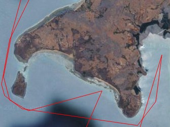
About 25 miles south of Rantabe Bay we eased our way between the rocky buttresses that flank northern Nosy Mitsio and anchored inside the bay at S12°54.5 E48°34.7 in 27' (8m) over sandy mud. This was a lovely place, with several small thatch-hut villages along the shores and nice hills for walking. You can leave the dinghy on the beach and explore. We found the people friendly and happy to have us wandering their hills and footpaths in the warm sun. They are a bit spoiled when it comes to trading, however, as charter boats frequent this bay and the tourists are happy to part with Euros or dollars for lobster, goat or fish. We struggled to trade lobster for our filet knife, mask and snorkel and fish hooks. Speaking French is very helpful. This island group is reported to have good snorkeling/diving near some of its northern islets, (upper left, and center, in the photo) but we were busy with a yacht rescue and didn't have time to check it out. Local trading dhows often come here from Nosy Be. It's fun to see how they careen the dhows on the beach at low tide, off-load the goods, then wait for the rising water to set them afloat again. So who needs an anchor?? |
 See a large map of our Hellville anchorage |
Nosy Be. We anchored off Hellville town at S13°24.4 E48°17.0 in 31' (9m) over mud. Be careful going far into the bay - it looks nice and open but it shoals rapidly near the edges (probably an old reef). If you haven't already, read the cautions on dinghies here, written above. When we left the boat to travel inland we left Ocelot in Crater Bay (S13°24.0 E48°13.0) in 26' (8m) over sandy mud. For security we had someone from a charter company (now defunct we hear) sleep on the boat, and keep a daily look-out. This bay was less hectic than Hellville, seemed more protected from the shifting winds, but once ashore you have a long walk then taxi ride to town. Crater Bay did attract a small pod of humpback dolphins who leisurely patrolled the anchorage at high tides. |
 See a large map of our Nosy Komba anchorage |
Nearby bustling Nosy Be is Nosy Komba, (S13°26.5 E48°21.1) a lovely little island with several villages, handicrafts for sale (carvings and drawn-thread work especially), and friendly people. Be careful of the rocks to starboard as you enter the bay, as they sometimes don't show very well. There's a nice forest walk, and lemurs to see, touch, and feed. There is a tiny ($1) fee to see the lemurs (which are wild), but it's worth it, as it provides incentive for the people to continue to protect these lovely, gentle animals. Take bananas if you want to feel a small silky creature on your shoulder! Follow the signs up the hill to the "maki" as they are called. The lemur guides speak English and are quite knowledgeable about this local species, the Black Lemur. Above the botanical park the path continues up and up to some nice forest and a few view points. Oh, and there are a couple little bars ashore if you want to kick back with a cool beer. We stopped here several times, sometimes spending the night, or at times just as a day sail from Hellville. |
 See a large map of our Sakatia anchorage |
On the western side of Nosy Be lies the small, tranquil island of Sakatia. We were unable to visit in 2007, but on our return we spent several lovely days here. Some yachties spend months, as this is the most protected, safe anchorage near Nosy Be, and has clear, clean water with some nice snorkeling. The tide ebbs to the north here, and can run up to a knot or more. Most boats anchor off John Shepherd's Sakatia Towers (S13°18.1 E48°10.7) in 12‑25' (4‑8m) over sand. Now that John has married and moved back to South Africa you can visit our friends Nel and Des, ex‑cruisers who have built a place behind and to the left of John's low-key hostel on the hill overlooking the anchorage (now leased to a fishing charter group). Nel and Des have a barge shuttle linking to their taxis to Hellville on Nosy Be. If you don't want the hassle of a trip to town yourself, they might be able to arrange for someone to pick up all your shopping and provide you with a detailed accounting on their return. Their staff of taxi drivers pay local prices for produce and pass it on to you. If you want to travel for a few days, Nel and Des might be able to arrange for your boat to be watched. |
 See a large map of our Tani Keli anchorage |
Petite Tani Keli (S13°29.2 E48°14.3) is a beautiful stop en route to or from Russian Bay, or a day trip on its own from Nosy Be. As this island has the clearest water along this part of the coast we stopped here to do a bit of snorkeling and to scrub the hull. Holding wasn't great, though, and we struggled to find depth over sand, not coral (which we won't anchor on). Mid-day the area can be busy with day-trippers from the hotels on Nosy Be, but you may be lucky and get it all to yourself! We didn't stay overnight, but if you do, be sure to allow for the inevitable wind shift! |
 See a large map of our Russian Bay anchorage |
Many cruisers enjoyed Russian Bay (S13°32.0 E48°00.8) for the walks guided by a local named Paul, and the camaraderie of the South African couple that lives there. Lisa does wash, and can supply you with drinking water and cool beers. We were late in the season (late October) and still had to make South Africa before the beginning of cyclone season so we didn't explore this large bay to the extent it deserved. There are several anchorages in the bay. We anchored in the northern end, just near the entrance. Lisa's place is to the south, farther in. Apparently Russian Bay got it's name because a Russian warship used to base here, sailing out to pirate passing freighters before it ran out of fuel. |
 See a large map of our Honey River anchorage |
We left Russian Bay mid-morning and had a great sail for about 4 hours, south, to Honey River (S13°42.8 E47°54.0) shown on the charts as Baramahamay Bay. We arrived in time to meet the chief's wife and purchase a liter of fresh honey that the villagers collect from wild bees in the hills behind the village. The whole bay is well protected and surrounded by lush green hills and small villages. With more time, a walk in the hills would be great. We did get to wander the chief's village, photograph the women, children and the pet black lemur, and see how the huts are constructed of wooden poles and thatch. As with other coastal anchorages on the mainland of Madagascar, the water is not clear, and there are numerous shoal areas, especially deeper into the interior where rivers flow into the bay leaving silt. |
 See a large map of our Nosy Shaba anchorage |
Sailing past several off-shore islands, we succumbed to temptation and pulled into (almost) uninhabited Nosy Shaba (S14°21.8 E47°37.9). Here, on the west side, we found white sand (it was too late in the day for snorkeling), some shelling to be had, and a nice walk on the grassy hills overlooking the sea. With more time, many of these off-shore islands are worth exploring! But if you plan to spend the night you need to be prepared for the wind to shift around after the land cools off a bit. Or else treat it as a day anchorage only. True to form, the on-shore breeze turned at about 9 pm, putting us on a lee shore, with a bit of fetch from the east kicking up an uncomfortable chop. Luckily we had a GPS track to follow from cruisers who had obviously had the same problem a couple years before! We pulled the anchor and motored straight across 8 miles to the mainland where (in the dark) we tucked into the shore at a little spot called Mahavanga (S14°21.0 E47°42.0). We spent a calm night, anchored in 20' (6m) over mud/sand, in the lee of Madagascar. |
 See a large map of our Moramba Bay anchorage |
We left early the next morning, as we had many miles to cover. Luckily, with the flat seas and nice winds abeam, we made awesome time, sometimes seeing 9 knots as we sailed with some of the larger dhows plying the coast. Sailing close to shore we had great views of the stark red-soiled land cut by sharp black rock formations and sparse greenery in the form of thorn trees and the occasional baobab. We arrived at what was to be one of our all-time favorite anchorages in Madagascar, Moramba Bay (S14°53.6 E47°19.8) by early afternoon. The anchorages (lots of nooks and crannies to tuck into, depending on the wind direction) are nestled between small rocky karst outcroppings that look like sharp mushrooms sprouting from the sea. Holding is excellent in 23' (7m) over mud/sand. On the islands stands of stocky, fleshy, other-worldly baobabs tower over lesser trees. The bird life was prolific with the large, all-black Greater Vasa Parrots prominent in the trees and dozens of Dimorphic Egrets (they appear equally in white or dark plumage) in their rookeries. Perched at the highest point in the trees, Madagascar Sacred Ibises balanced against the afternoon breeze, their black necks, heads, legs and tails contrasting with their white backs and bellies. Small beaches afforded great places for yachitie get-togethers in the evening. Again, with time, it would have been a great place to explore for more than the 2 nights that we did. |
 See a large map of Mahajamba Bay anchorage |
We scooted down the coast south from Moramaba Bay, finding shelter that night in the red waters of huge Mahajamba Bay at S15°17.0 E46°58.7 (yes, all these anchorages sound the same!). We anchored in 13' (4m) in good-holding sand. Amanda and Sue went ashore to the tiny village that was no more than a set of grass and thatch huts hugging the sandy beach, just behind a low wall of dunes. We offered a whole bag of used clothing in exchange for some fresh fruit (we could see the mango trees behind the huts) but it took quite a while to get the idea across. Only one person in the village spoke French! And our Malagasy was limited to a brief Hello and Thank you! When they figured it all out, it was like Christmas on the beach with the men all trying on the hats and T-shirts, and they gave us the biggest mango we've ever seen! The beach combing was pretty non-descript, but it was good to stretch our legs. By the way, we found most Malagasy villagers to be cautiously friendly, and very honest. We never worried about leaving our inflatable dinghy and outboard hauled up on a beach anywhere (except in the big towns like Hellville and Majunga). We left early the next morning (wide open bays are good for those dawn get-aways) as we had 40 miles to make by early afternoon. Luckily the winds stayed true, and we scooted along at over 8 knots. |
 See a large map of our Majunga anchorage |
At this point, we were wanting to top up the diesel jerry jugs for our Mozambique Channel crossing, and it had been more than a week since seeing fresh produce, so it was very tempting to go into this region's major town, Majunga (S15°42.6 E46°18.7). Unfortunately, within the past few weeks there had been a rather gruesome theft/stabbing on a French yacht just off the town. So when we arrived at 3pm we already knew that we didn't want to spend the night. This old colonial town must have been quite lovely in its hay-day. Today it is run-down and harbors a few very nasty men who the law seems unable (or unwilling) to apprehend. Jon ferried Amanda and Sue ashore with diesel jugs, then returned to Ocelot to await their return. The town was bustling with rickshaws and taxis. Cash could be changed by the Indian merchants near the open air market. Once we had the diesel and were ready to cart it from the taxi to the wharf, a couple boat boys appeared, all willing to help -- for about 5 times the going rate in Nosy Be! We settled on giving them an old hat and some Ariary (a dollar or so). |
 See a large map of our Ketsepy anchorage |
Wanting to sleep soundly, we motored on across the bay where we found a spot for Ocelot in 22' (7m) in mud, near the village of Ketsepy (S15°46.3 E46°14.6). We walked the beach at sunset and in chatting to both the lodge owners and the truckers who congregated there we learned that none of them had heard of the troubles with armed robbery on sailboats in Majunga. Hmmmm. Closed ears? No interest? Too common an occurrence? Or just the isolation of small villages that keep to themselves. We deployed our Radio Shack intruder detection system and DID sleep soundly. |
 See a large map of our Bali Bay anchorage |
 Baly Bay, Madagascar, east side beach |
Our last day on the coast was a long one -- 65 nautical miles to be made, all in daylight, with any luck. We left Ketsepy at 0500 and were lucky with good breezes that allowed us to average over 8 knots all day. At 1750 we dropped the hook in big, open Bali Bay (S16°00.7 E45°16.8) in 17' (5m) in mud. Because of the size of the bay we were subjected to the changing winds and the chop, so it was a rolly night. Early the next morning we motored 5 miles across the Bay to try the east side (S16°00.4 E45°21.0, 20' or 6m over mud). Twelve hours later found us back at our first anchorage! Can't help it. We like to be comfortable!! It wasn't quite the totally relaxing last day before a passage that we'd hoped it would be, but we did get some rest. There was an abandoned village ashore, and Amanda and Sue did a bit of exploring, but the rocky beach was not too hospitable.
We jumped off for Mozambique on November 3, 2007. You can read about our passage (and our too-close encounter with a whale) in our Africa Newsletters. Our second Madagascar visit was in August 2009, as we headed north from South Africa towards Seychelles. That time we arrived from Mayotte, and spent our time in the northern part of the Madagascar coast. Those sailing stories are recounted in our Mayotte Newsletters.
Indian Cruising Info:
Related Pages:
Cruising Info:
Top Level: Home | Destinations | Cruising Info | Underwater | Boat Guests | Ocelot | Sue | Jon | Amanda | Chris | Site Map | Make a Comment
|
If our information is useful, you can help by making a donation |
Copyright © 2000‑ Contact: Jon and Sue Hacking -- HackingFamily.com, svOcelot.com. All rights reserved.